


Earthquakes in the Valencia region (this includes Benidorm)
Earthquakes (Un Terremoto in Spanish) in the Valencia region - Earth tremors are not that unusual in our area, and most are minor and nothing to worry about and are just part of the natural way energy is released, caused by the fact that beneath the Mediterranean there are vast tectonic plates which are in constant motion. This coastline was once attached to Africa and there are a series of fault lines right along the Murcia, Almeria and Alicante coastline, these are the African and Eurasian tectonic plates.
The south of Alicante is an area of strong tectonic activity and the last tremor of medium intensity occurred on March 24th, 2019 off the coast of Cape Palos (Murcia), where the IGN recorded a 4.3 on the seismic scale of Richter.
The southeast of the peninsula is the region with the highest seismic risk.
What is an Earthquake?
An earthquake is an intense shaking of Earth’s surface. The shaking is caused by movements in Earth’s outermost layer.
Why Do Earthquakes Happen?
Although the Earth looks very solid from the surface, it’s actually very active just below the surface. The Earth is made of four basic layers: a solid crust, a hot, nearly solid mantle, a liquid outer core and a solid inner core.
The solid crust and top, stiff layer of the mantle make up a region called the lithosphere. The lithosphere isn’t a continuous piece that wraps around the whole Earth like an eggshell. It’s actually made up of giant puzzle pieces called tectonic plates. Tectonic plates are constantly shifting as they drift around on the viscous, or slowly flowing, mantle layer below.
This non-stop movement causes stress on Earth’s crust. When the stresses get too large, it leads to cracks called faults. When tectonic plates move, it also causes movements at the faults. An earthquake is the sudden movement of Earth’s crust at a fault line.

How are Earthquakes measured?
The energy from an earthquake travels through Earth in vibrations called seismic waves. Scientists can measure these seismic waves on instruments called seismometer. A seismometer detects seismic waves below the instrument and records them as a series of zig-zags.
Scientists can determine the time, location and intensity of an earthquake from the information recorded by a seismometer. This record also provides information about the rocks the seismic waves travelled through.
Are there volcanoes of the Valencian Community? Yes we have 2, both classed as dormant
The most spectacular of those we have in the Valencian territory is perhaps the Cofrentes Volcano,located in the Cerro de Agrás,500 meters high. This volcano was the subject of research in the mid-seventies, due to the upcoming construction of the Cofrentes Nuclear Power Plant. Studies show that the crater experienced its last activity about 2 million years ago. However, in its depths there is still some activity, which some nearby spas take advantage of, through its thermal waters.

Crater of the Cofrentes volcano.
The other volcano in our territory, and the youngest, is located in the Columbretes Islands (Castellón). These islands are known to be of volcanic origin. Several studies suggest that this area had volcanic activity only 300,000 years ago. Specifically in one of the Islands that form this small archipelago off the coast of Castellón, in the so-called Illa Grossa.
For a volcano to be considered active it must have undergone an eruption in the last 10,000 years
Earthquakes in the Valencia region
During the 19th century several earthquakes in the Valencia region caused serious damage and casualties. The most notable was the Torrevieja earthquake on March 21st in 1829, which completely destroyed the town and caused serious damage in Guardamar, Almoradí and Orihuela with hundreds of fatalities. This earthquake reached a magnitude of 6.6 (measured on the scale used at the time) and resulted in 389 dead and 377 wounded.
February 2021 - The national earthquake institute has just finished fitting the latest generation detectors in Guardamar del Segura and Elche, which work in real time, and will enable scientists to measure any increase in activity quicker.
Recent earthquakes in the Valencia Region 2024
15th June - At 16.31 saw a low level (2.8 on the Richter scale) earthquake at a point Southeast of Guadalest. The epicentre was practically at the surface, and no damage or personal injuries have been reported.
6th April - Small earthquake registered in Hondón de las Nieves (El Fondó de les Neus) in the province of Alicante at 21:16. Magnitude 2.3 at a depth of 7 kilometers
Recent earthquakes in the Valencia Region 2023
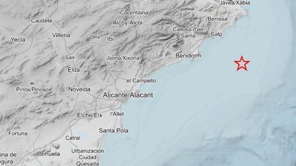
19th November - On Sunday morning at 07.38hrs, an earthquake was registered at 1.6, on the Richter scale, 40km off the coast between Benidorm and Calpe, at a depth of 5km.
7th October - An earthquake of 2.4 on the Richter scale was registered at 11.33, with its epicentre at 15 km of depth, and off the town of La Vilajoyosa.
4th September - Three earthquakes in the space of just 11 hours in our province of Alicante. Two were registered in the early hours of Monday at the Sierra de Crevillent and Hondón de las Nieves, which registered at 2.9 and 2.0 on the Richter scale respectively. The third tremor was on Monday morning at 10.57, with its epicentre to the north east of Santa Pola, with a depth of 15 km, and an intensity of 1.7 on the Richter scale. Despite its relatively low strength it was quite widely felt in the area.
15th August - At 09.33 an earthquake of 1.7 on the Richter scale was recorded, with its epicentre off the coast between Benidorm and L'Alfàs del Pi.
This earthquake is the first to occur this year on the coast of the Marina Baixa. In 2022 only one was recorded, on August 6th off the coast of La Vila Joiosa of 1.5 degrees of magnitude.
30th July - The National Geographic Institute has released details of an earthquake that occured, in the early hours of Sunday morning, with its epicentre inland of Villajoyosa. The tremor registered 3.9 on the Richter scale, had its centre 2Km below the earths surface, and was felt across a wide area. No injuries or damage was reported, but several calls were made to emergency ervices, and people "felt the earth move" in places as far apart as Banyeres de Mariola, Alcoy, Cocentaina, El Campello, Santa Vicent del Raspeig, Alicante, Elda, and Benidorm.
28th March - Yet another small earthquake was registered at 06.55, off the coast of Torrevieja and Guardamar. The quake with an intensity of 1.8 on the Richter scale had an epicentre 9Km below the seabed.
9th March - Recorded on the coast between NE Calp and Moraira, between Cala Llobella and Cala Baladrar, next to the CV-746 road, at 21:44. The epicentre was located 6 km deep.
24th March - Three small earthquakes were registered yesterday in the same area, just off the coast in front of Torrevieja. The first was registered at 09.00, and the last at 23.48, with this last one registering at 3.0 on the Richter scale. The quakes were felt in the towns of Torrevieja, Guardamar, Orihuela Costa, Los Montesinos and Rojales, as well as being noted in some areas of the Baixa Vinalopó, such as Elche.
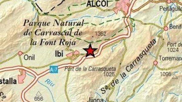
3rd to 6th March - The town of IBI, which is situated inland of Benidorm is pretty much "earthquake central" at the moment....A "nest" of seven earthquakes (as they describe it in Spanish) were registered between Friday and Monday. They were all between 1.5 and 1.8 on the Richter scale.
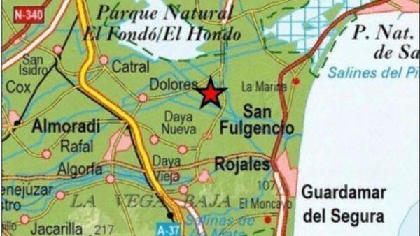
27th February - The municipality of San Fulgencio, Vega Baja region, registered seismic movement measuring 2.1 on the Richter scale. The earthquake occurred at 21:52 in an area between the Oasis urbanization and the Los Azahares de Dolores industrial estate, with the epicenter located 10km deep.
23rd February - Recorded at 23:55, 88Km off the coast between Alicante and Santa Pola, registering 1.8 on the Richter scale, at a depth of 18km.
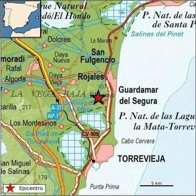
31st January - We started the month with an earthquake, and we have also ended it with one. Guardamar del Segura registers an earthquake of 1.6 magnitude. The earthquake occurred at 00:34 hours, located in the coastal area between the municipality of Guardamar del Segura and Cabo Cervera, in the municipality of Torrevieja.
19th January - Registered at 05.38, measuring 2.9 on the Richter scale. The epicenter was 80km from the coast of the municipality of Santa Pola and about 10 kilometers deep.
15th January - Crevillent, measuring 2.2 degrees with epicenter in Crevillent. The seismic movement occurred 2km deep, at 12.28 in the Taibilla channel area, near the Sierra de Crevillent and the national road 340, reports Rafa Jover.
7th January - Just off the coast of Alicante, no information available.
1st January - Recorded on New Years day, at 09.41, with its epicentre at Alcoy, (Inland from Benidorm). The tremor registered at 1.9 on the Richter scale, at a depth of 12Km.
Recent earthquakes in the Valencia Region 2022
20th December - Registered at 01.18, measuring 2.2 on the Richter scale, in the municipality of San Miguel de Salinas (region of Vega Baja), near the La Pedrera reservoir and the CV-925 road, the epicenter was 6 km deep.
This seismic movement, greater than 1.5 degrees, is the second that occurs in the municipality of San Miguel de Salinas and the fourteenth in the Vega Baja region so far this year; while the province of Alicante already has 62 earthquakes in 2022.
22nd November - An earthquake was registered at Los Montesinos, (Torrevieja) right in the Chaparral urbanization at 1.30, registering 2.2 on the Richter scale. no damage was caused according to Emergency services.
22nd September - An earthquake occurred in Guardamar del Segura at 08.15 this morning, registering 2.6 on the Richter scale, the epicentre was recorded just southwest of Guardamar. No damage has been reported.
29th August - The province of Alicante has registered three earthquakes, in less than 24 hours. All three were in the areas of l'Alcoià and el Alto Vinalopó, in the interior of our province. The three quakes came relatively close to each other, in time and also situation...With the first the strongest at 3.0 on the Richter scale, which is the strongest of the year, not just in our province, but also our region.
20th July - A small earthquake was registered yesterday at 10.17, with the epicentre just off the coast of Alicante, 20km from the coast. The quake of registered 1.8 on the Richter scale, at a depth of 1 km.
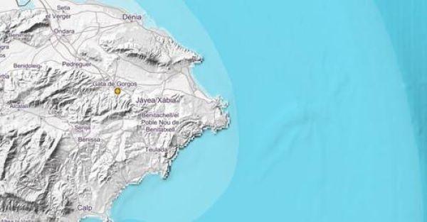
22nd June - Wednesday afternoon at 14.21 saw an earthquake of 2.1 on the Richter scale registered in the area of Gata de Gorgos, in an area north of Benidorm and inland of Javea. The epicentre was registered 30 kilometres deep, very close to the urban area and near Carrer Sant Josep.
This is the third earthquake that has occured this year in the region of Marina Alta, after the two registered on March 8 in El Verger and Els Poblets.
14th March - Santa Pola Area, recorded at 05:06 and registered 1.8 on the Richter scale and was located 19 kilometres from the coast off Cape Santa Pola, northeast of the island of Tabarca.
8th/9th March Two earth tremors with 13 minutes between them were registered in the early hours of Tuesday night/Wednesday morning in the area of the Marina Alta, They had their epicentres in El Verger and in Els Poblets.
The first measured 1.7 degrees magnitude on the Richter scale, occurred at 01:58 in the municipality of El Verger, 10 kilometres deep.
The second earthquake, of 1.8 degrees of magnitude, was registered at 02:11 in the municipality of Els Poblets, also 10 kilometres deep.
24th January 2022 - Santa Pola area, (just south of Alicante city). The quake measured 1.8 on the Richter scale had its epicentre between the island of Tabarca and the mainland at Santa Pola and was recorded at 14.22, 7km deep.

This is the seventh earthquake registered this January, in the province of Alicante, counting those registered in Salinas (Alto Vinalopó), Crevillent (Baix Vinalopó) and Planes (El Comtat) and the two of Tibi (L ́Alcoià) and two of Santa Pola.