
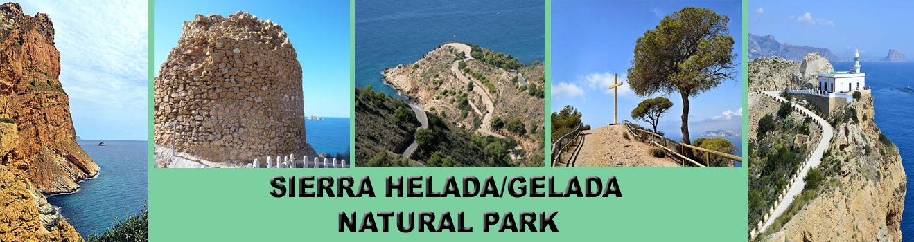
Sierra Helada Benidorm/Gelada Natural Park
Sierra Helada Benidorm is a natural park and includes the areas of Benidorm, L'Alfàs del Pì and Altea. Sierra Helada means Ice mountain in Spanish. The name is said to come from the way the cliffs look from the sea on a moonlit night. Fisherman on the Mediterranean Sea found that the rocks looked like an iceberg and also due to the cliffs orientation which creates a colder macro-climate.
It is a protected site with a total surface area of 5,564 Hectares, 4,920 hectares of which are a marine reserve and in these waters are some of the most interesting underwater areas of the Mediterranean peninsular. The coastline is one of the most beautiful in the Valencian region. The park also includes three islands: Illot de la Mitjana, the Illot de Benidorm and the Illots of Olla and la Galera.
The summit of the Sierra Helada is 439 meters above the Mediterranean Sea.
The terrestrial part of the park is mostly made up of limestone which is millions of years old and protected fossil dunes, you will find a large variety of protected native plants. This area also incorporates Benidorm´s famous Cross (La Cruz), Watchtowers and Albir Lighthouse.
In ancient times, the main use of the Sierra Helada was for mining for the extraction of ochre. There is evidence of its use since the time of the Phoenicians. This resource was exploited until the middle of the last century. The main remains are found on the way to the lighthouse of L’Albir and in the Cala del tío Ximo area.
There are 3 walks available - Albir lighthouse, Punta del Cavallo. For the more adventurous, the crossing of the Serra Gelada is perfect for hiking, with a distance of 8 km and a duration of about 4 hours.

The Blue Route (EASY)
"Punta del Cavallo" or "Punta de la Escaleta"
Length of route: 8,7 km (round trip), plus the 700 m of Ti Ximo Cove.
Duration: From 2h to 2h 30 min Maximum Elevation: 75 m
Accessibility: Road paved.
Hiking. Cycling. Wheelchairs.
Difficulty: Easy
Start the tour at the end of the Levante beach head up hill on the road leading to the Benikaktus hotel on the street Alcalde Manuel Catalan Chana.
Via the paved road, we will proceed straight up, passing to the left the route to the cross (route 2, yellow) and proceed until we find a detour which descends to the viewing point of the Punta Llisera and Tio Ximo Cove.
Along the cove you can see the old ocher mines, where, not long ago, Tio Ximo worked with his donkeys.
Watchtower: back on the road and to the right hand side access a road with restricted to motor vehicles, where we will go to the Punta del Cavall, a seventeenth century watchtower.

From here there are some of the best views of the cliffs of the Serra Gelada and very close to them, Illa Mitjana. Both here and the Punta Bombarda in Albir, are excellent vantage points, hence why in medieval times, the watchtowers were built to alert the public of the presence of pirates.
Red Route
Albir lighthouse
Length of route: 5 KM (round trip)
Duration: 1 h 30 m to 2 hours
Maximum Altitude: 112 meters
Accessibility: Paved route. Trekking Cycling. Wheelchairs.
Difficulty: Easy
Starting from the Information Point Albir (Alfas del Pi), walk up the street "Cami de la Cantera," which as its name suggests ends in an old quarry from which stone was quarried, turn to the left at the streets "Syrio" and "Neptuno", until we reached a parking area where one of the entrances to the Natural Park can be located, the route to the Albir lighthouse.
A few metres ahead there is a small recreation area. From here also the yellow route starts that climbs to the crest of the Serra Gelada. "Caleta del Metge" and viewpoint We head up the paved route towards a tunnel in the mountain, but just before on the left hand side is a dirt track which descends to a small cove known as " Metge Cove, "and soon after there is a circular balcony with a magnificent view of the bay of Altea in the background the Penyal d'Ifach (Calpe), surrounded by spectacular mountains. Arriving at the entrance of the tunnel, we can find another smaller viewing point.

Ocher mines cove "La Mina" We continue to the lighthouse and after travelling 300 metres, we come across the path that slopes down gently to the mines of Phoenician origin and subsequent Roman exploitation, from which ocher was extracted to be used as a dye well into the century, when it fell into disuse after the introduction of other new substances for this activity. The "Boca of the Balena" About 500 metres after the tunnel we arrive at a bend in the road where to the right and above you can see in the shade of the mountain a natural hollow known as the "Mouth of The Balena "or" Cova de Bou ". Albir lighthouse at the end of the road we reach the El Faro del Albir where access is not permitted. Just before reaching the light house there is another viewing point to the right.
Off the coast of Albir, there are lots of fish farms which attract dolphins. These Fish farms help repopulate the fish in the Mediterranean sea by allowing the fisherman to only catch fish from the farms.
Sierra Helada Benidorm
Yellow Route
The 7 Peaks of the Sierra Helada
Feeling fit? you can walk from the Benidorm cross to Albir. This is the most challenging walk of the Sierra Gelada natural park as the walk passes along the seven peaks between Benidorm and Albir. You can walk in either direction but remember to arrange transport at the other end as it is one way. The panoramic views are breath-taking, and well worth all the climbing up and down.
From Benidorm the walk starts at the Cross. There is then a marked pathway up and down seven peaks, before arriving in Albir at the Sierra Gelada visitor centre. Many walkers prefer to get a lift to the Cross.
This is only recommended for people with moderately high fitness levels and full mobility. Distance 12.8km one-way trip. Moderately difficult, but worth the challenge! Allow 4.5 hours.
Crossing the Serra Gelada
Length of route: 12,8 km (one way)
Duration: 4h to 4h 30 min
Maximum height: 438 m
Accessibility: suitable only for Hiking
Difficulty: Moderate-high.
Due to being quite a moderately strenuous route it is suggested you take plenty of drinking water with you as there is no where to stop along the way. The route in some areas is steep up and down..
If starting from Albir - Start at the recreational area of the Albir, on (red), with a steady climb in zigzag that starts with a stone step path to reach the access road to telecommunication station , passing next to an old quarry.
"Alt del Governador" At the end of this path we will reach the highest point of the Serra Gelada (438 m), where a telecommunications station is located. Continuing down a paved road will link back to the path (4).
Near the edge of the cliff is a trig point where we can see the magnificent cuts of the cliff, and view specimens of the yellow-legged gull flying several hundred feet below our feet.. "L'Illa Mitjana" The route through the Sierra continues with continuous ups and downs, passing the ruins of an old coast guard house and a small well in the valley.
Halfway we find an area where there is a small area of pines where we can relax for a few moments, offering a beautiful view of the "Illa Mitjana."

The Cross The last stretch of mountain route passes through a high area where we can contemplate again the view of Benidorm from Sierra Helada and the cliffs. From this milestone we must be careful to keep to the path that passes through low vegetation or on bare rock. A few minutes later you come to a cross located above the Raco de l'Oix, where there is a tarmac track which connects to the blue route.
- There are no drinking fountains in the Nature Park. Please ensure that you bring sufficient water and food.
- During the winter months it may be necessary to bring a woollen hat and sun screen.
- Wear special footwear for hiking.
- Although it is a coastal range, do not underestimate the challenges of the Sierra Gelada Mountain.
- Before embarking on a route calculate the unevenness, slope or gradient and geography or orography of the area.
- If you take a dog with you it must be kept on a leash.
- Please respect the flora and fauna in the area at all times.
- Be extremely careful if it is raining in case of landslides.
Join our Facebook Group